Sea Level Rise - now and in the future
The challenge of climate change is here, in Boston, now. As the century progresses, the effects of climate change will grow…. Since 1991, Boston has experienced 21 events that triggered federal or state disaster declarations. As the climate changes, the likelihood of coastal and riverine flooding—as well as other hazards, like stormwater flooding and extreme heat—will increase. The pace of relative sea level rise is accelerating. Over the entire twentieth century, sea levels rose about nine inches relative to land. Another eight inches of relative sea level rise may happen by 2030, almost three times faster. By 2050, sea levels may be as much as 1.5 feet higher than they were in 2000, and by 2070, they may be as much as 3 feet higher than in 2000.’(Climate Ready Boston p1-3, 2016)
Risks to Charlestown
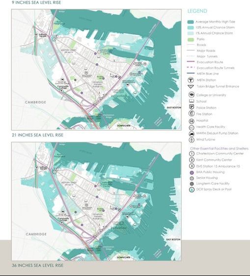
Charlestown’s exposure to near-term (immediate) impacts (include) low-lying land east of Sullivan Square. As soon as the 2050s, the areas flooded in low probability storms will increase by over 150 percent, mostly due to a large expansion of the floodplain inland via low-lying land near Sullivan Square. Once coastal floods coming from the Mystic River cross Rutherford Avenue, a large expansion of the floodplain is expected to the south, along low-lying area that was filled. More frequent and expansive coastal flooding in inland areas of Charlestown is expected in the late century, with a higher probability of both flooding inland east of Sullivan Square.’ (Climate Ready Boston p152, 2016) (See Predicted Sea Level Rise in Charlestown from Climate Ready Boston, 2016 below.)
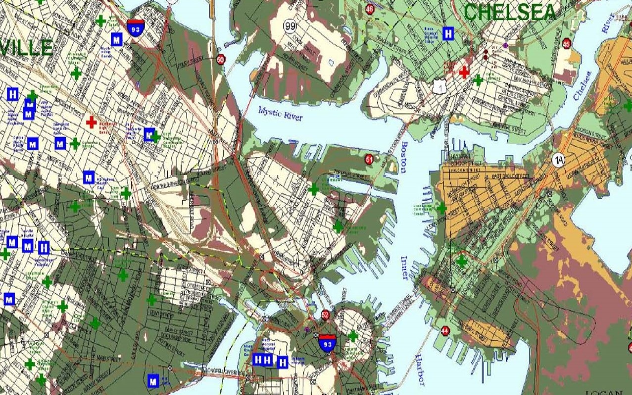
According to current Sea, Lake and Overland Surges from Hurricanes (SLOSH) models and maps produced by the National Hurricane Center (NOAA, 2017) , if a category 2 hurricane arrives in Boston at high tide with current sea levels, Sullivan Square would be under water. (See SLOSH map below from National Hurricane Center showing what flooding will occur if hurricanes were to happen now at high tide. Sullivan Square is inundated with only a category 1 storm.)
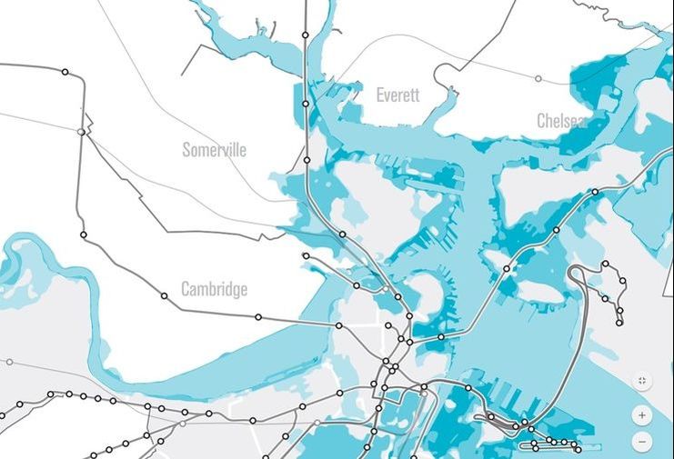
To put this in perspective, if Hurricane Sandy in 2012 had arrived just 5 hours earlier, Sullivan Square and all of Rutherford Ave would have been flooded. The projections in the Climate Ready Boston and GoBoston2030 plans shown that within 50 years’ time, Sullivan Square and much of the land around it including a fair amount of the Rutherford Ave corridor will be flooded at least once per month during a seasonal high tide. As can be seen, the water will flow from Sullivan Square along the route of the Orange Line through the Hood Plant, Bunker Hill Community College, and down to Paul Revere Park. (See Charlestown Flooding Predictions for 2017- Sullivan Square will flood Monthly at High Tide- GoBoston2030.)
With the realities of current flood susceptibility and climate change predictions, allowing an underpass to remain in the Sullivan Square area will only exacerbate the impacts of the flood scenarios. In contrast, building all streets on the surface, with profiles as high as possible, can mitigate the risk. Further, an underpass not only keeps the flood water ‘channel’ open, but also ensure that the critical Rutherford Ave evacuation route out of Boston would be useless in a large scale flood event.
Protecting the Neighborhood
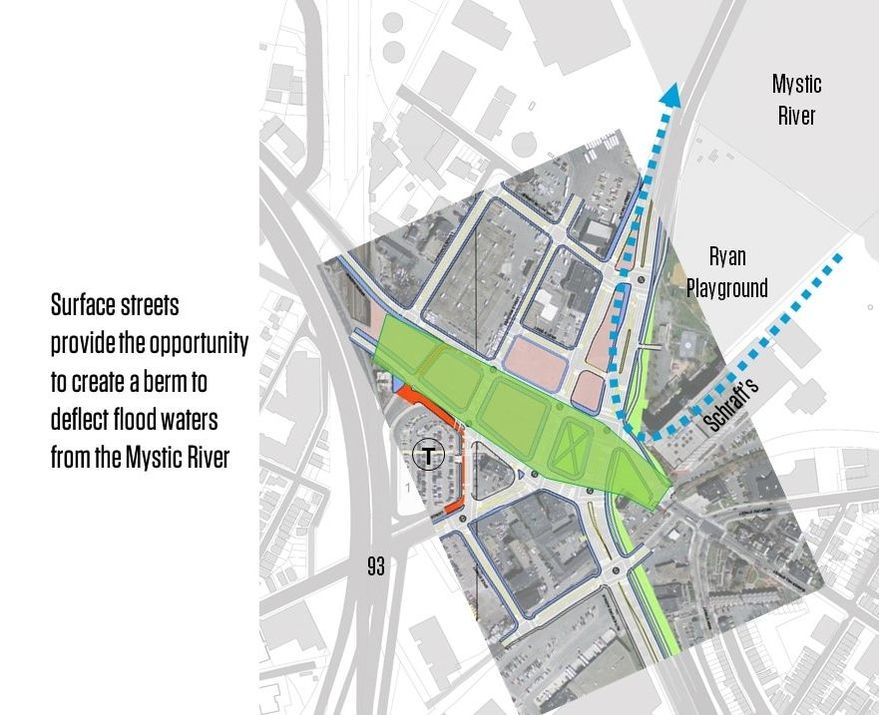
In the re-design of Sullivan Square, there is a unique opportunity to protect the low lying lands west of the Square. Current models predict that flood waters flow through a small ‘channel’ of land in Sullivan Square, and then the water spreads out to the west to impact the entire Rutherford Ave corridor and areas of Somerville and Cambridge. If this ‘channel’ is filled and Sullivan Square raised in elevation, a berm could be created to prevent flood waters from pouring in from the Mystic River during large storm events. (See berm concept below by Offshoots, Inc. landscape architects.)
In contrast, a surface option design for Sullivan Square can be built above predicted flood elevations, and with a bermed profile, potentially save entire neighborhoods behind it from flood inundation in large scale events.
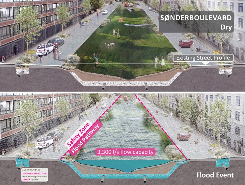
Lastly, the Surface Option for the roadways creates a 50’ wide green space area along the length of the entire corridor. Taking inspiration from the Dutch, this green corridor could be used to collect, filter and infiltrate storm water to keep it out of storm water pipes that can exacerbate flooding scenarios. (See Copenhagen Strategic Flood Masterplan by Ramboll Studio Dreiseitl below.)
Lastly, the Surface Option for the roadways creates a 50’ wide green space area along the length of the entire corridor. Taking inspiration from the Dutch, this green corridor could be used to collect, filter and infiltrate storm water to keep it out of storm water pipes that can exacerbate flooding scenarios. (See Copenhagen Strategic Flood Masterplan by Ramboll Studio Dreiseitl below.)
Photos
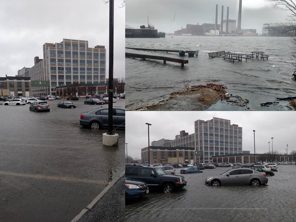
Schrafft's Center - Friday, March 2, 2018


