City Square to Austin Street - Surface Option (May 2017)
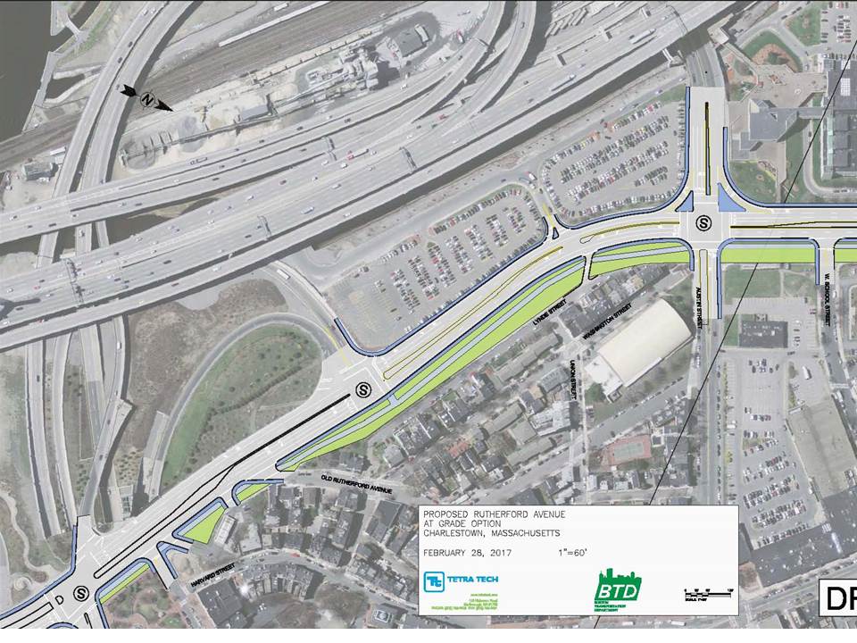
In the Surface Option, Rutherford Avenue is moved 36 feet away from the neighborhood at the narrowest point and 75 feet away at the widest point. This provides a large new area for a linear park, which can include landscaping (green), a shared use path (light blue), and a separate sidewalk (dark blue). It is possible that one more southbound surface lane might be needed to handle the volume of vehicles, but that would only reduce the open space by 11-12 feet.
City Square Park can be seen in the bottom left hand corner, while Austin Street is the intersection near the right side. The large white roof is the ice rink.
City Square Park can be seen in the bottom left hand corner, while Austin Street is the intersection near the right side. The large white roof is the ice rink.
City Square to Austin Street - Underpass Option (May 2017)
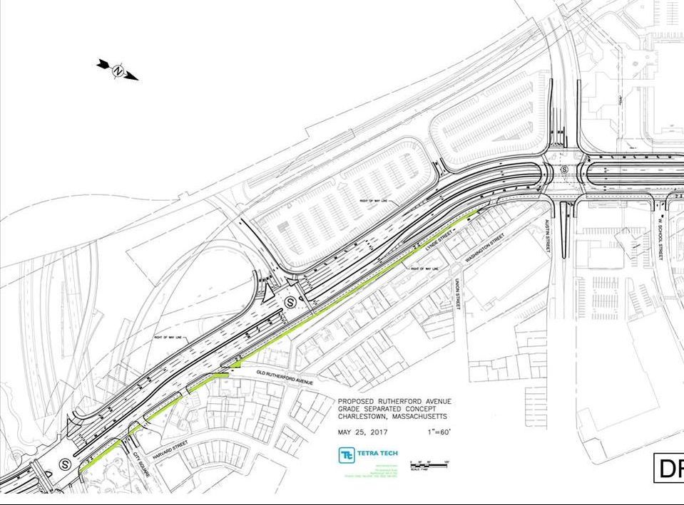
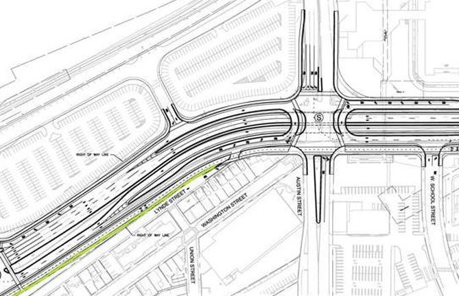
This shows the same area from City Square Park to Austin Street at the same scale as the visual above. The Rutherford Avenue is away from the neighborhood 18 feet at the narrowest point and 24 feet at the widest point. A shared use path will take up 10-12 feet of that space. In this graphic, the greet is potential landscaping and the shared use path is white. There is no separate sidewalk. At the end of Washington Street, near the ice rink, the existing sidewalk and part of the road will be converted into shared use path, but there will not be space for much greenery - perhaps 6 feet of landscaping.
The Underpass Option has nearly 72,000 less square feet of open space in this area than the Surface Option. That is equal to 1.63 City Square Parks.
The Underpass Option has nearly 72,000 less square feet of open space in this area than the Surface Option. That is equal to 1.63 City Square Parks.
Austin Street - Surface Option (May 2017)
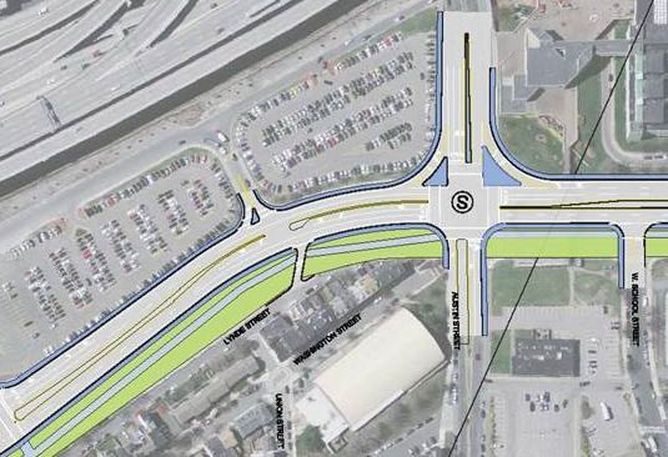
The most recent BTD plan eliminates the "free rights" between Rutherford Avenue and the Gilmore Bridge (shown as blue triangles) and changes the corners into 90 degree turns. Since 600+ vehicles make these turns per hour during rush hours, this will actually constrain traffic flow. RCIC will ask that they be reinstated, but with a pedestrian crossing signal that is separate from the rest of the intersection.
The open space shown here is approximately 65 feet wide. A safe pedestrian refuge will need to be added in the center of the street to allow for safe crossings, so that will take a few feet from the open space. In addition, another southbound lane may be needed, but around 50 feet of separation would still remain on the neighborhood side.
The open space shown here is approximately 65 feet wide. A safe pedestrian refuge will need to be added in the center of the street to allow for safe crossings, so that will take a few feet from the open space. In addition, another southbound lane may be needed, but around 50 feet of separation would still remain on the neighborhood side.
Austin Street - Underpass Option (May 2017)
This shows the same area near Austin Street at the same scale as above. The open space near the intersection is so small that it was not possible to color any green landscaping. The ADA ramp for the pedestrian bridge can be seen as a light horizontal rectangle adjacent to the shared use path. This means that the shared use path is equal to the existing sidewalk plus part of the existing travel lane.
Pedestrians trying to cross from the neighborhood to Community College Station will need to wait to cross the street while standing in the middle of the shared use path. This will be a dangerous situation as an increased number of cyclists will be coming through the area on the path.
Here, the "free rights" are eliminated creating a 90 degree turn onto and off of the Gilmore Bridge. This will slow turning movements (which is generally positive in a pedestrian environment) which will require more space to be dedicated to vehicle stacking near BHCC. The right turns should be reinstated with a pedestrian crossing that is timed separately from the rest of the intersection.
Question arise about why any funds would be spent for this reconstruction when it offers so little change.
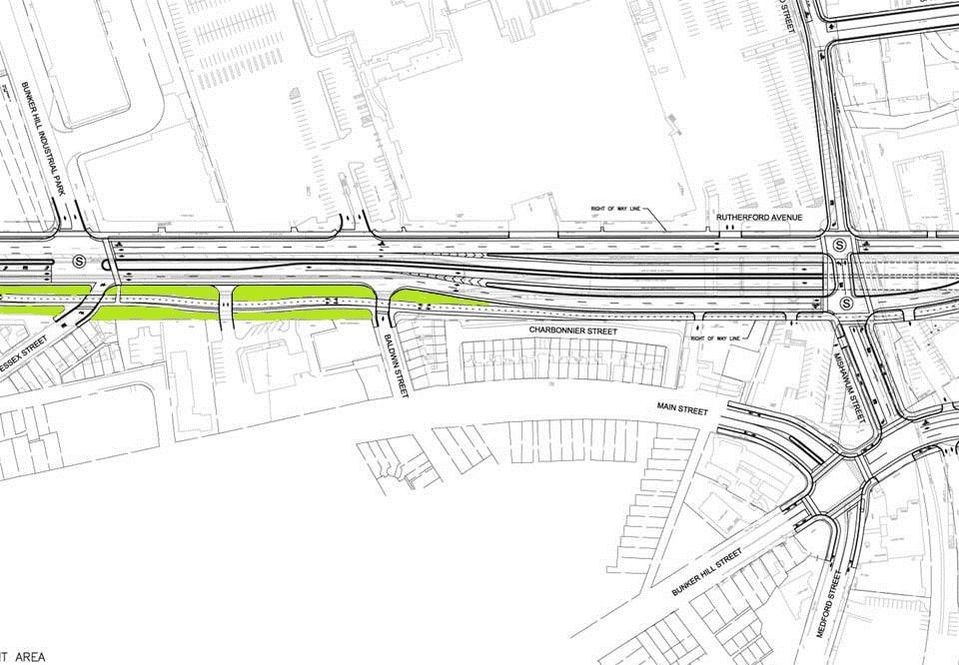
Essex Street to Mishawum Street - Surface Option (May 2017)
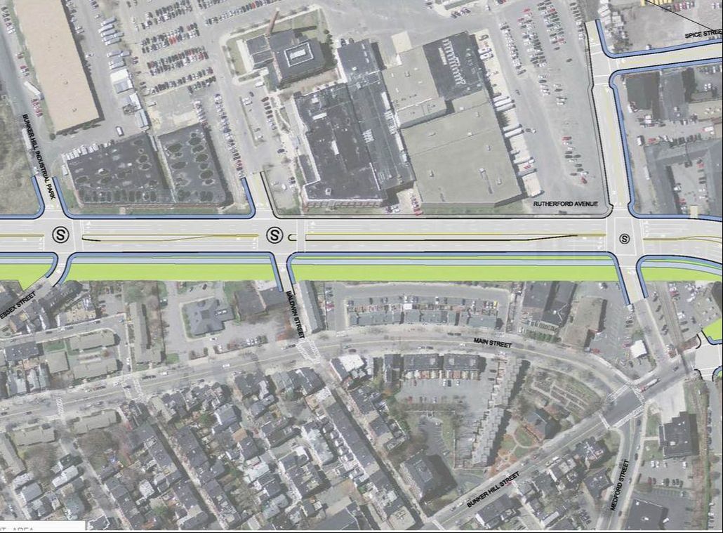
The Surface Option in this area moves vehicles 65 to 68 feet away from the neighborhood, providing space for landscaping (green), a shared use path (light blue), and a separate sidewalk (dark blue). This graphic shows Essex Street at the left to just past Mishawum Street on the right.
Essex Street to Mishawum Street - Underpass Option (May 2017)
This shows the same area between Essex Street and Mishawum Street at the same scale as above. Here it can be seen that the road which is 60-62 feet away from the neighborhood near Essex Street, to 35 feet near Dunstable street, and then into its existing alignment near Charbonnier Street. In this graphic, the area for the shared use path is the existing sidewalk plus the existing street parking lane.
Importantly, a recent meeting with BTD (11/2/17) revealed that there was an error in the design for this location and the separation between Charbonnier and Mishawum Street will be increased. As shown above, pedestrians trying to cross at Mishawum Street will need to wait in the middle of the shared use path for the light to change. If not remedied, this will be a dangerous situation as an increased number of cyclists will be coming through the area.
Importantly, a recent meeting with BTD (11/2/17) revealed that there was an error in the design for this location and the separation between Charbonnier and Mishawum Street will be increased. As shown above, pedestrians trying to cross at Mishawum Street will need to wait in the middle of the shared use path for the light to change. If not remedied, this will be a dangerous situation as an increased number of cyclists will be coming through the area.
Sullivan Square - Surface Option (May 2017)
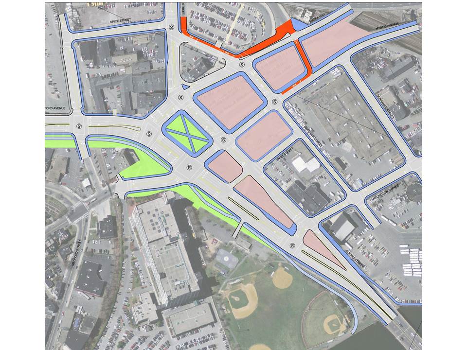
This is the Surface Option presented in May 2017, and seen multiple times prior. Blocks shown in pink are developable and the blue surrounding them represents sidewalks. The block shaded in green with a blue X is a future square park to serve the neighborhood. A total of 7 blocks are seen as developable, or 8 if you consider relocating the square park.
From a traffic perspective, this design does not work due to the high volumes where Rutherford Ave meets Main Street/Maffa Way coming from Somerville and where Rutherford Ave meets Main Street coming from the neighborhood. That is because there are so many lanes meeting each other and the intersections are very complicated, with multiple left turn movements and pedestrian crossings.
This means that BTD has never shown the neighborhood a Surface Option that works at Sullivan Square so that we can consider its merits. Outside transportation experts suggest that an increase in the number of one-way streets and adding more lanes to some of the outside streets would result in a Surface Option that could handle the traffic volumes.
Sullivan Square - Underpass Option (May 2017)
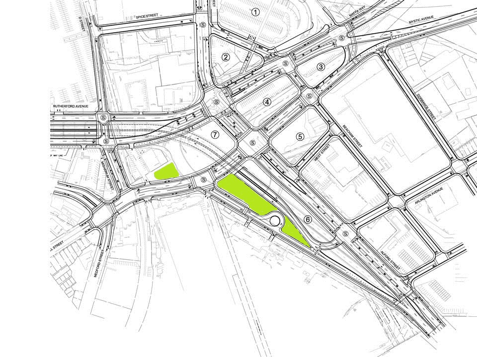
This shows the same section of Sullivan Square at the same scale as above. The underpass travels from the left side, down at an angle, and rises to the surface next to Block 6. Travelers coming from Everett toward downtown Boston will need to make a left at a signalized intersection to get into the underpass.
At a recent meeting (11/2/17), BTD indicated they have made improvements to this design, including increasing the size of Block 6 so that it can be developed. This is done by removing the turnaround shown near Ryan Playground and eliminating the single northbound lane traveling from Main Street toward Everett. They have also added to the shared use path so that it reaches the Alford Street Bridge (in this version, the path terminates at Block 7.
At a recent meeting (11/2/17), BTD indicated they have made improvements to this design, including increasing the size of Block 6 so that it can be developed. This is done by removing the turnaround shown near Ryan Playground and eliminating the single northbound lane traveling from Main Street toward Everett. They have also added to the shared use path so that it reaches the Alford Street Bridge (in this version, the path terminates at Block 7.
Sullivan Square - Underpass Option Buildable Blocks (May 2017)
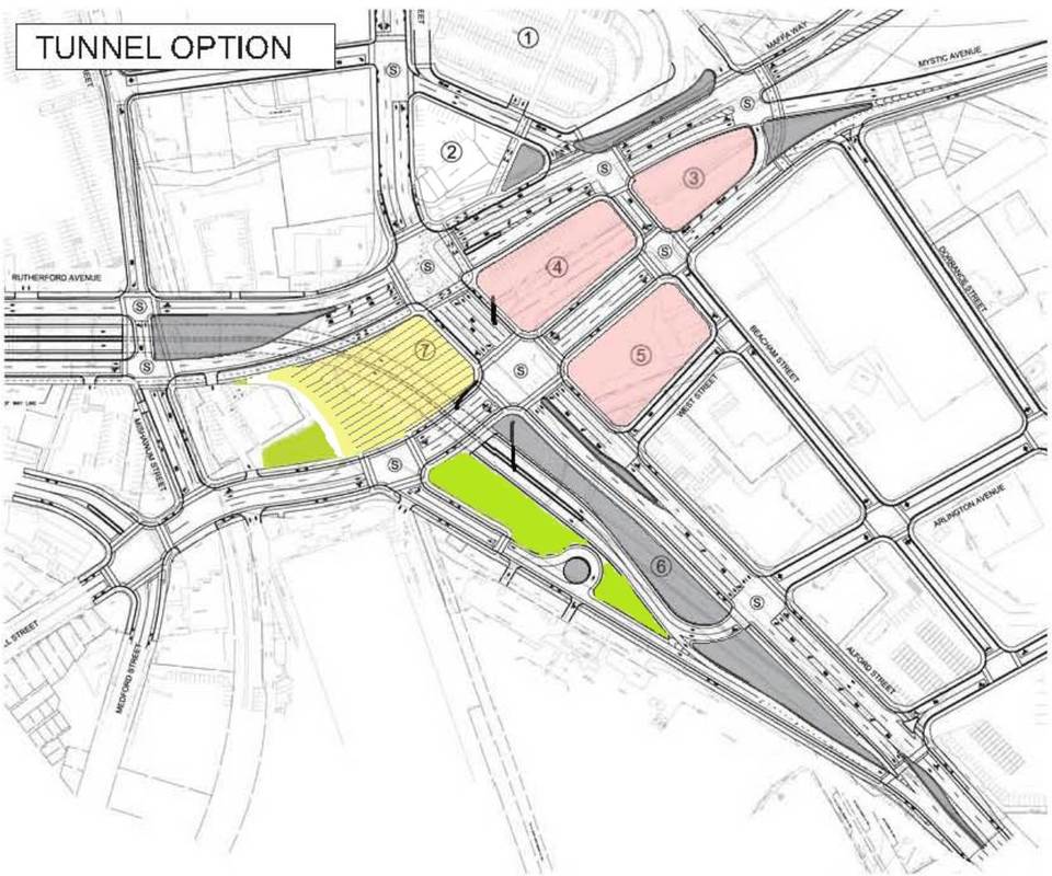
This graphic shows three developable blocks based upon the May 2017 plan (see pink), plus one air rights development site (see yellow with stripes). BTD has indicated that they are making modifications so that Block 6 will be buildable.
Of significance is the fact that an entire block near Somerville is eliminated in this plan. In the MAPC Reuse Study, one of those blocks was to be considered for a parking garage that would serve the entire area. That would reduce the need for parking on the other blocks and would make the area more pedestrian friendly as there would be fewer curb cuts leading to parking garages. It could also help with event parking as people go to the Garden for concerns and events.
Of significance is the fact that an entire block near Somerville is eliminated in this plan. In the MAPC Reuse Study, one of those blocks was to be considered for a parking garage that would serve the entire area. That would reduce the need for parking on the other blocks and would make the area more pedestrian friendly as there would be fewer curb cuts leading to parking garages. It could also help with event parking as people go to the Garden for concerns and events.


