Austin Street - What will the options look like?
This section includes Surface Option and Underpass Option designs
from 2013 and 2016-17.
from 2013 and 2016-17.
The Current Underpass
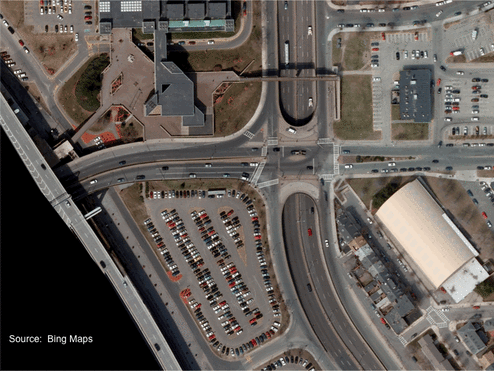
This is an aerial photo of the current intersection and key buildings:
- Top left corner is the Bunker Hill Community College.
- Top right corner (dark grey roof) is the 99 restaurant.
- Bottom right corner (white roof) is the hockey rink.
- Bottom left corner is one of the parking lots for the community college.
Surface Option
Overlay of the 2013 Surface Option on the Aerial Photo
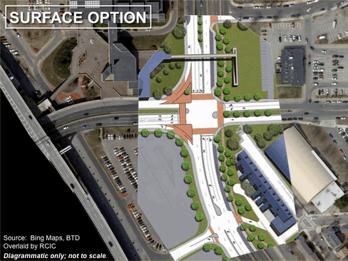
The Surface Option plan is added to the aerial photo.
This plan has:
- 2 northbound lanes
- 2 southbound lanes
- 1 southbound left turn lane
- 1 southbound right turn
Notice the distance between the ADA ramp from the pedestrian bridge and the edge of the new roadway.
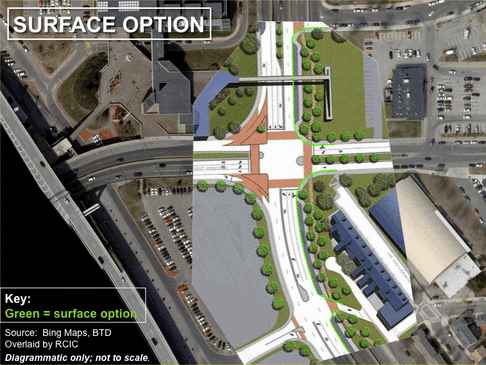
A green line is added to show the outside edge of moving traffic.
In the Surface Option, this is the line between the moving traffic and the parking lane.
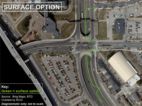
The Surface Option plan is removed so the green line is now on top of the photo. This shows how far the moving traffic will be pushed away from the neighborhood - 50 feet or more.
This line would be continued the full length of the project area - from the Washington Street bridge to the Alford Street bridge.
Overlay of the 2013 Underpass Option on the Aerial Photo
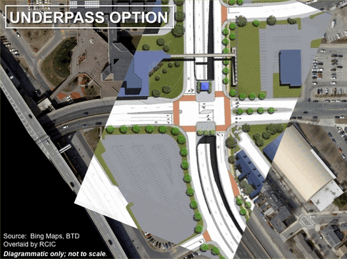
The 2013 Underpass Option plan is added to the aerial photo. This alternative has:
- 2 northbound surface lanes
- 2 northbound underpass lanes
- 1 southbound/left turn surface lane
- 1 southbound right turn lane
- 2 southbound underpass lanes
(This reduces the number of right turn lanes from 2 (existing) to 1 (proposed). This would constrain vehicles going to Cambridge. if a 2nd right turn lane was added, the open space would get smaller.)
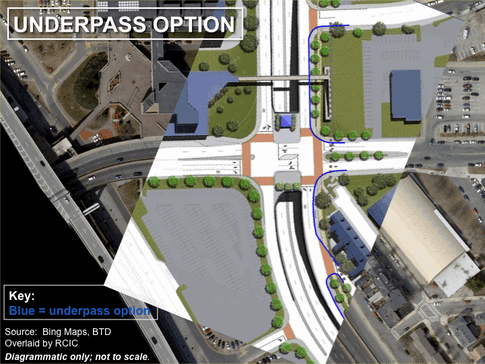
A blue line is added to show the outside edge of moving traffic. In the Underpass Option, this is the line between the moving traffic and the sidewalk. (There is no surface parking in this option.)
Note that in this option, there is almost no space for trees or landscaping next to the homes at the end of Washington Street (bottom right). There is only space for the shared use path and the sidewalk.
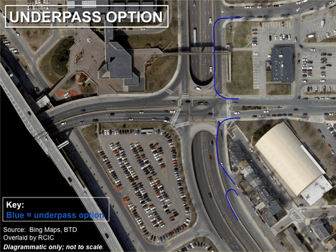
The Underpass Option plan is removed so the blue line is now on top of the photo. This shows how far the moving traffic will be pushed away from the neighborhood ~ 22 feet.
There's a big difference in space gained between the two 2013 options.
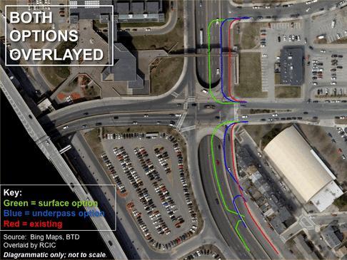
This shows the difference between today (red line), the Underpass Option (blue line), and the Surface Option (green line) in terms of how much land will be returned to Charlestown residents.
2016-17 Surface Option
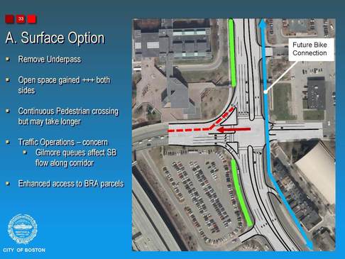
The most recent plans for Austin Street include a number of changes that are not consistent with the 2013 version and negatively affect the amount of open space. First, the 2016-17 graphics show and state that open space will be added on both sides of the street. This was never considered in 2013, and residents have been clear with BTD that they want to maximize open space on the neighborhood side.
In addition, BTD has added a 3rd southbound lane at the intersection, which has no purpose since the road is 2 lanes immediately to the north (a 3rd lane may be needed to the south for the traffic coming from the Prison Point Bridge, but it is not needed at the intersection). In addition, an extraordinarily wide median (more than 1 lane wide) has also been added, which was not seen previously. Although a pedestrian refuge is needed for a safe crossing, if the road is only 5 lanes wide as in the original surface option (2 north, 2 south, and 1 left turn), some people will be able to cross in one light and the refuge space will not have to be too large.
These three changes make the revised surface option appear to be the same as the revised underpass option, which is not the case. The design of the new surface option is a significant step backward that will need to be fixed.
2016-17 Southbound Underpass Option (1-way)
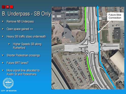
This new option includes an underpass in the southbound direction only. This is because the northbound traffic numbers are much lower.
This alternative has:
- 2 northbound surface lanes
- 2 southbound surface lanes (one is a left/through lane)
- 2 southbound underpass lanes
- 2 surface right turn lanes
This is only approximately 2 lanes (22-24 feet) narrower than today.
This alternative has:
- 2 northbound surface lanes
- 2 southbound surface lanes (one is a left/through lane)
- 2 southbound underpass lanes
- 2 surface right turn lanes
This is only approximately 2 lanes (22-24 feet) narrower than today.
2016-17 North- and Southbound Underpass Option (2-ways)
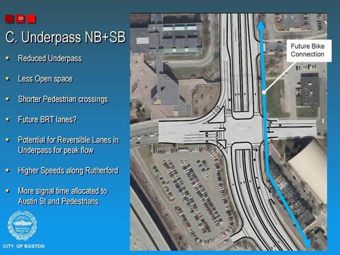
This option includes 2 underpasses, both of which are 2 lanes wide, which is exactly what exists today. The blue line showing "future bike connection" is on top of the ADA ramp from the pedestrian bridge. In addition, the open space that was placed on the Community College side of the street has disappeared. This means there is effectively no change from today.
Underpass Length 2016-17
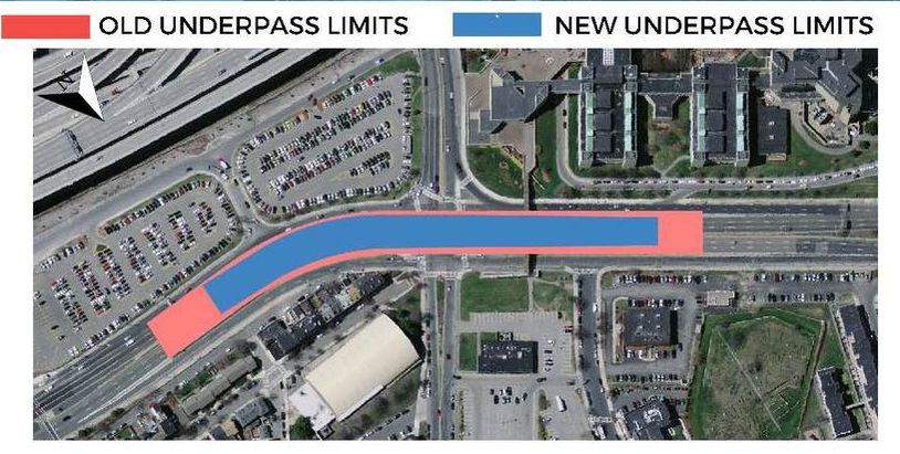
BTD has stated that it will make the underpasses shorter in the newer versions by making the decline and incline steeper. They indicate the existing underpass is 1,800 feet long and the proposed one is 1,000 feet long. However, the red shaded area in the graphic below understates the extent of the underpasses and the lanes leading to the underpasses today. Given this, it is unclear how long the proposed new underpass(es) would be.


